1. Physical features of India
India, officially known as the Republic of India, is a vast and diverse country located in South Asia, characterized by a unique blend of physical and political features that shape its identity, governance, and geographical significance.
Geographically, India spans an area of approximately 3.28 million square kilometers, making it the seventh-largest country in the world and the second-most populous, with over 1.4 billion people.
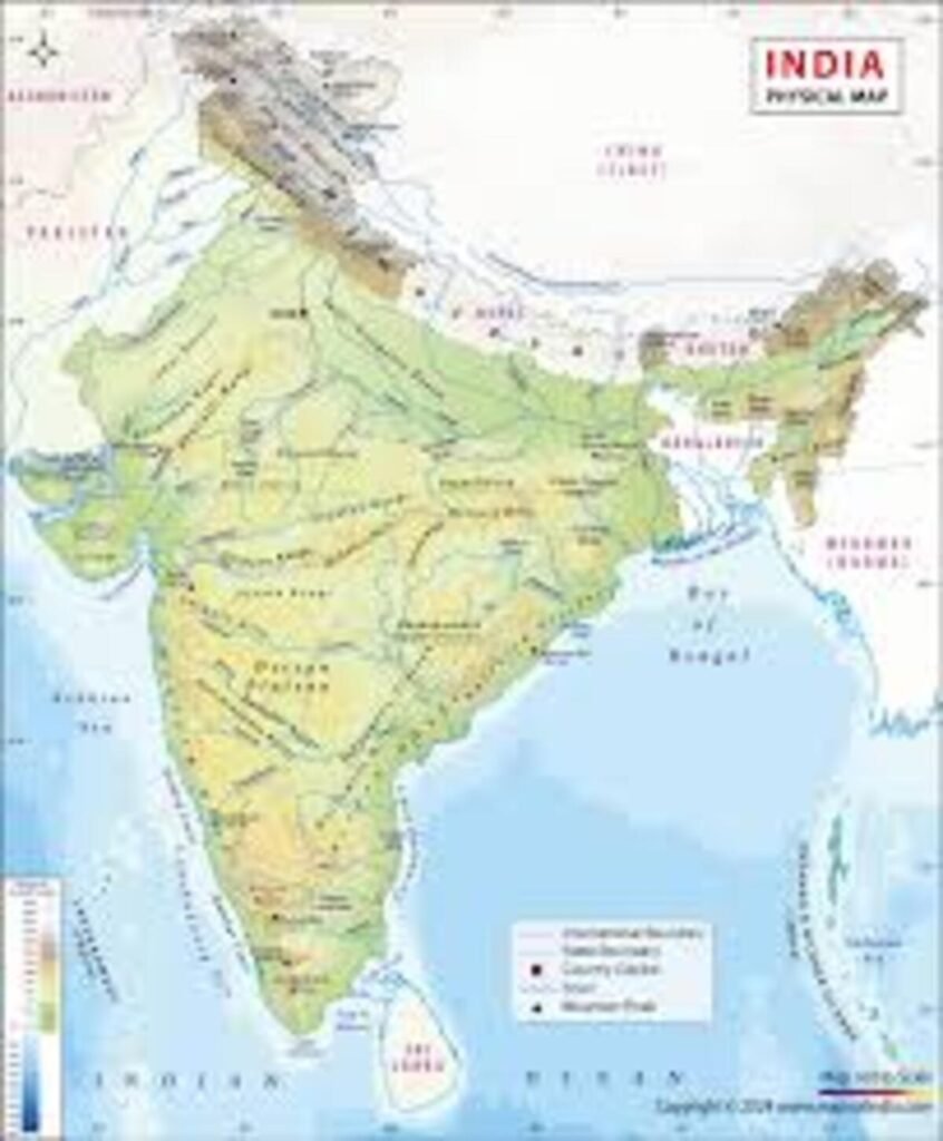
Its physical features are immensely varied and can be broadly categorized into six major physiographic divisions: the Northern Mountains, the Indo-Gangetic Plain, the Peninsular Plateau, the Indian Desert, the Coastal Plains, and the Islands.
The Northern Mountains include the towering Himalayan ranges, which act as a natural barrier and climatic divide, stretching across the northern borders with peaks such as Mount Kanchenjunga, the highest in India.
The Himalayas are divided into three ranges—Himadri (Greater Himalayas), Himachal (Lesser Himalayas), and Shiwaliks (Outer Himalayas)—each playing crucial roles in water resources, biodiversity, and weather regulation.
South of the Himalayas lies the fertile Indo-Gangetic Plain, formed by three major rivers—the Ganga, Yamuna, and Brahmaputra—and their tributaries.
This alluvial plain is agriculturally productive and densely populated, forming the heartland of Indian civilization.
Moving further south, the Peninsular Plateau, one of the oldest landmasses on Earth, comprises the Central Highlands and Deccan Plateau, bordered by the Western and Eastern Ghats.
This region is rich in minerals and features varied terrain including hills, forests, and river valleys.
To the northwest lies the Thar Desert, or the Great Indian Desert, characterized by arid conditions, sandy soil, and extreme temperatures.
Along the eastern and western fringes of the country are the Coastal Plains, which include the Eastern Coastal Plain and Western Coastal Plain, both important for agriculture, trade, and fishing.
Additionally, India has two major groups of islands: the Andaman and Nicobar Islands in the Bay of Bengal and the Lakshadweep Islands in the Arabian Sea, both adding to the country’s maritime importance and biodiversity.
Geography
India, located in the southern part of the Asian continent, is a geographically, physically, and politically diverse country, occupying a unique position in the world due to its size, population, landscape, and strategic importance.
Geographically, India lies entirely in the Northern Hemisphere and is situated between latitudes 8°4’N and 37°6’N, and longitudes 68°7’E and 97°25’E. It is bordered by the Himalayas to the north, which act as a natural geographic barrier separating the Indian subcontinent from the rest of Asia, and is flanked by the Arabian Sea in the west, the Bay of Bengal in the east, and the Indian Ocean to the south, making it a prominent maritime nation.
The Tropic of Cancer (23°30’N) divides the country almost in half, contributing to diverse climatic zones ranging from tropical in the south to temperate in the north.
Physically, the country can be broadly divided into six major physiographic regions: the Northern Mountains (including the Himalayas), the North Indian Plains, the Peninsular Plateau, the Indian Desert, the Coastal Plains, and the Islands.
The Himalayas, with some of the world’s tallest peaks including Kanchenjunga, are divided into the Greater, Lesser, and Outer Himalayas, playing a vital role in influencing India’s climate by preventing cold Central Asian winds and giving rise to perennial rivers like the Ganga, Yamuna, and Brahmaputra.
South of the Himalayas lies the Indo-Gangetic Plain, one of the most fertile and densely populated areas in the world, thanks to its rich alluvial soil and extensive river systems, making it a key agricultural hub.
The Peninsular Plateau, encompassing the Deccan Plateau and the Central Highlands, is one of the oldest landforms in the world, consisting of hard igneous and metamorphic rocks, and is rich in minerals like iron, manganese, and coal, supporting a strong mining and industrial sector.
To the northwest lies the Thar Desert, characterized by arid conditions, sandy terrain, and sparse vegetation, while the eastern and western coasts consist of narrow coastal plains that are agriculturally rich and house some of India’s most important ports like Mumbai, Chennai, and Kolkata.
India also possesses two major island groups: the Andaman and Nicobar Islands in the Bay of Bengal and the Lakshadweep Islands in the Arabian Sea, which are not only biodiversity hotspots but also hold strategic and economic significance due to their proximity to international shipping routes.
From a climatic perspective, India experiences a monsoon climate, with four major seasons: winter, summer, monsoon, and post-monsoon (autumn).
The southwest monsoon brings the majority of the rainfall between June and September, vital for agriculture.
Geographically, the country’s extensive river systems such as the Ganga, Brahmaputra, Godavari, Krishna, and Mahanadi support irrigation, hydroelectric power, and transport, making water resources crucial for the nation’s development.
The country’s topography includes various elevation zones, from the high peaks of the Himalayas to the low-lying coastal areas and river deltas like the Sundarbans, which are ecologically sensitive and prone to flooding.
Additionally, the varied geography contributes to a wide range of natural vegetation zones—tropical rainforests in the Western Ghats and northeastern states, deciduous forests in central India, alpine vegetation in the Himalayan region, and desert vegetation in Rajasthan—each supporting diverse wildlife and ecosystems protected in over 100 national parks and wildlife sanctuaries.
Natural disasters such as earthquakes (especially in the Himalayan belt), floods, droughts, and cyclones (especially along the eastern coast) are geographical risks that India continually mitigates through disaster preparedness and environmental planning.
2.Political features of India
Politically, India is a sovereign, socialist, secular, and democratic republic, as enshrined in its Constitution, which came into effect on January 26, 1950.
It is a federal parliamentary democratic republic where powers are divided between the central government and individual state governments.
The President of India is the constitutional head of state, while the Prime Minister is the head of government and wields executive authority.
India’s federal structure comprises 28 states and 8 Union Territories, each with its own government, legislature, and administrative machinery, except for Union Territories which are governed directly or partially by the central government.
This political division helps in the decentralized administration of a vast and diverse population.
Each state is divided into districts, and further into tehsils and villages, ensuring grassroots governance through the Panchayati Raj system in rural areas. The Indian Parliament consists of two houses: the Lok Sabha (House of the People) and the Rajya Sabha (Council of States), which together legislate on central matters.
Political representation in India is based on democratic elections held at regular intervals, with adult suffrage for all citizens over the age of 18.
India is known for its multiparty system, where regional parties often play significant roles in state and sometimes national politics.
The major national parties include the Indian National Congress (INC), Bharatiya Janta Party (BJP), and several others, with frequent coalitions forming to create majority governments.
The political boundaries of India are defined by its international borders, which it shares with Pakistan and Afghanistan in the northwest, China, Nepal, and Bhutan in the north, and Bangladesh and Myanmar in the east.
To the south, India is bounded by the Indian Ocean, with the Arabian Sea on the west and the Bay of Bengal on the east.
India’s border with Pakistan is marked by the contentious region of Jammu and Kashmir, particularly the Line of Control (LoC), which remains a significant geopolitical issue.
Similarly, India’s border with China, particularly in the regions of Ladakh and Arunachal Pradesh, has been a point of tension and periodic military standoffs.
Despite these challenges, India plays a significant role in regional diplomacy, economic cooperation, and international forums such as the United Nations, BRICS, SAARC, and G20.
Internally, India’s political structure enables diverse linguistic, cultural, and religious communities to coexist and participate in governance, though it also poses challenges in maintaining national unity and addressing regional disparities.
Language plays a vital political role, as the country recognizes 22 scheduled languages in its Constitution, and each state often operates in its predominant regional language.
Furthermore, India’s physical and political features are deeply interrelated.
For example, the Himalayan region is not only significant for its ecological and climatic roles but also forms a strategic frontier with neighboring countries.
The Indo-Gangetic Plain, being agriculturally rich, supports dense populations and contributes to India’s political weight in national policymaking.
The mineral-rich Deccan Plateau underpins industrial development in states like Maharashtra, Karnataka, and Telangana, influencing economic and political priorities.
The coastal areas, due to ports and trade, become hubs of economic activity, drawing political focus toward infrastructure and maritime security.
The island territories serve not only as tourist destinations and ecological hotspots but also have geopolitical significance, enhancing India’s naval presence in the Indian Ocean Region.
Political decisions regarding environmental conservation, development, and disaster management are often influenced by the physical characteristics of the region.
For instance, flood management in the Gangetic basin, drought relief in the Deccan, and cyclone preparedness along the eastern coast are recurring themes in policy discourse.
Similarly, infrastructure projects like the Golden Quadrilateral highway network, river interlinking schemes, and rural electrification take into account India’s vast and diverse physical terrain.
In summary, India’s physical features—from its mountains and plains to plateaus, coasts, and islands—form the geographical skeleton upon which the political framework operates.
This framework, rooted in democratic federalism, allows India to manage its diversity, ensure representation, and maintain unity in the face of complex internal and external challenges.
The integration of natural landscapes with political boundaries reflects India’s ability to adapt its governance to suit its environmental and demographic realities.
Both the physical and political landscapes continue to evolve with time, shaped by natural forces, historical legacies, socio-economic dynamics, and the aspirations of its people.
This dynamic interaction between geography and governance defines India not only as a land of variety but also as a resilient and enduring democracy on the global stage.
States and Their Capitals
| 1. Andhra Pradesh | Amravati | 15. Manipur | Imphal |
| 2. Arunachal Pradesh | Itanagar | 16.Meghalaya | Shillong |
| 3. Assam | Dispur | 17. Mizoram | Aizawl |
| 4. Bihar | Patna | 18. Nagaland | Kohima |
| 5. Chhattisgarh | Raipur | 19. Odisha | Bhubaneshwar |
| 6. Goa | Panaji | 20. Punjab | Chandigarh |
| 7. Gujarat | Ghandinagar | 21. Rajasthan | Jaipur |
| 8. Haryana | Chandigarh | 22. Sikkim | Gangtok |
| 9. Himachal Pradesh | Shimla | 23. Tamil Nadu | Chennai |
| 10. Jharkhand | Ranchi | 24. Telangana | Hyderabed |
| 11. Karnataka | Bengaluru | 25. Tripura | Agartala |
| 12. Kerala | Thiruvananthapuram | 26. Uttarakhand | Dehradun |
| 13. Madhya Pradesh | Bhopal | 27. Uttar Pradesh | Lucknow |
| 14. Maharashtra | Mumbai | 28. West Bengal | Kolkata |
Union Territories and Their Capitals
| 1. Andaman and Nicobar | Port Blair |
| 2. Chandigarh | Chandigarh |
| 3. Dadra and Nagar Haveli Daman & Diu | Daman |
| 4. Jammu and Kashmir | Srinagar/Jammu |
| 5. Ladakh | Leh |
| 6. Lakshadweep | Karavaratti |
| 7. National Capital Territory of Delhi | New Delhi |
| 8. Puducherry | Puducherry |